


My Earthquake Alerts - Map
4.76.41K Reviews
App Specs
- Version
- 26.5.0
- Updated On
- License
- Free
- Downloads
- 10,000,000+
- Developer
- JRustonApps B.V.
- Categories
- Weather
- Platform
- Android, iOS
Screenshots
 Analysis by AppCompare
I think an earthquake app makes the most sense when you know what you want it to do before an alert appears: help you notice activity, make the location easier to understand, and give you a useful next step. My Earthquake Alerts - Map is built around that sort of awareness. It is a free weather app from JRustonApps B.V., with a worldwide earthquake feed, alerts, and an interactive map. I find that combination more useful for keeping track of seismic activity than for treating a phone notification as a safety plan.
Start with the question you actually have
Before opening the app, I would decide whether I am checking on a place I live, following a trip, or simply trying to understand an event in the news. Those needs call for different views of the same information. A nearby alert matters to someone at home; a broader map can be more useful when checking activity across a region or another part of the world.
That distinction is worth keeping in mind because a global feed can become noisy if every event is equally important to you. I would use the available alert settings and filters to make the app serve a specific purpose, rather than leaving every possible update turned on and eventually ignoring them. For someone who follows earthquakes as a subject, broad coverage may be the point. For someone who only wants a local heads-up, selectivity is more valuable.
From notification to map
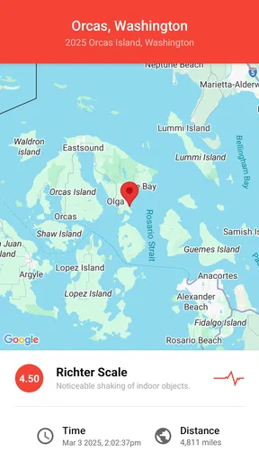
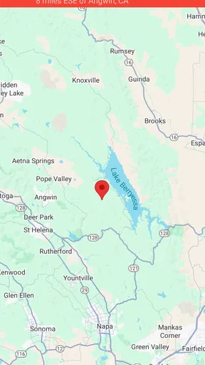
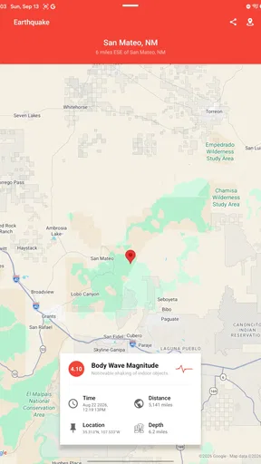
The practical flow is straightforward: an alert draws my attention, then the map gives me a geographic frame for the event. I can zoom in to examine the area or zoom out to see how it sits within a wider region. That handoff from a short notification to a visual overview is the app’s strongest everyday idea; a number or place name alone can be difficult to interpret if I do not know the geography.
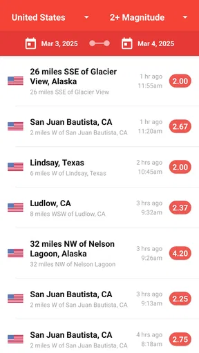
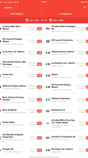
Filters for magnitude, distance, and time help narrow what appears. I would start with a recent time window and a distance relevant to the place I am checking, then widen the view if I need context. This is more useful than treating the feed as a running list to scroll without a question in mind. Historical information can also help when I want to compare an event with earlier activity, though I would use it to explore patterns rather than make predictions.
Where it fits in a routine
A realistic use is checking the app after hearing that an earthquake has happened near a city where a friend or family member lives. I can look at the event’s location on the map, adjust the view to understand the surrounding area, and then contact that person through my usual channel. The app can help me orient myself, but it cannot tell me whether a particular person is safe; that requires direct communication and dependable local information.
For travel, I would use it as one layer of awareness before and during a visit to an earthquake-prone region. I might check the map when planning a day out and keep relevant alerts enabled, while still relying on local guidance for preparedness and response. A map is useful context, not a substitute for knowing what to do where I am staying.
Worth Reading Before You Choose

Flipboard Shows What News Apps Must Do Beyond the Feed

Switching to Android Auto Means Rethinking Your Driving Routine

Google Calendar Makes a Crowded Week Easier to Manage

Ludo King Makes the Most of the Minutes Between Plans

Baby Panda World Brings Quick Play to Modern Phones, but Its Game Library Feels Busy

ESPN’s Live Game View Makes Following Close Games Easier
Getting Started with My Earthquake Alerts
First off, downloading My Earthquake Alerts - Map was a breeze. Available on both Android and iOS, it's just a tap away in your respective app store. Once installed, you’re greeted by a clean, user-friendly interface that's as intuitive as it is informative. No clutter, just the essentials right at your fingertips.
Features That Make It Stand Out
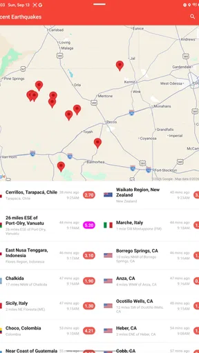
Now, let’s talk features. One of the coolest things about this app is its real-time alerts. Yes, you heard me right! The app diligently sends you notifications about earthquakes happening near your location or anywhere else in the world. You can customize your alert settings, which is perfect if you’re a globe-trotter or just someone who likes to stay updated.
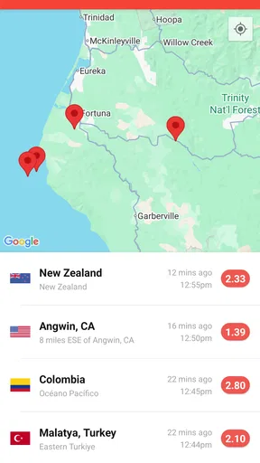
The app also boasts a detailed map interface where you can visually track seismic activities. It’s like having a mini earthquake monitoring station in your pocket. The map is interactive, allowing you to zoom in and out to get a better perspective of recent earthquakes.
The User Experience
Using the app feels incredibly intuitive. You don't need to be a tech wizard to navigate through it. The layout is straightforward, with tabs that guide you to the latest earthquakes, your customized alerts, and historical data. Speaking of historical data, the app provides information on past earthquakes, which is both fascinating and educational.
Another awesome feature is the option to filter earthquakes by magnitude, distance, and time. This way, you can focus on the data that matters most to you. Whether you’re a casual user or a die-hard seismology fan, My Earthquake Alerts has got you covered.
Choosing it over a general weather app
For a quick check of rain, temperature, or a week’s forecast, I would still reach for a conventional weather app. This one has a narrower job: following earthquake activity. Compared with a broad weather app that may include seismic information as one small part of a larger dashboard, its dedicated feed and map make earthquake details easier to focus on. If I need official instructions during an emergency, though, a local authority’s alerts and guidance matter more than any general-purpose app.
The app is a particularly good fit for curious users who like to check where an event occurred, travelers who want a simple way to follow activity around destinations, and people who prefer a map to a text-only feed. It may be less appealing if you want an all-in-one forecast, dislike notifications, or need a formal emergency-warning system. I would also avoid reading a quiet feed as proof that there is no risk: an activity tracker is useful for awareness, not a guarantee of safety.
Small choices that improve the experience
One useful habit is to make filters match the reason you installed the app. A local user can keep the distance and time window focused, while someone tracking global events may prefer a wider view and accept more alerts. If notifications become distracting, adjusting the scope is a better first move than abandoning the feed altogether. The trade-off is simple: broader coverage gives more context but asks for more attention.
I would also separate checking an event from deciding what it means. The map can help me see location and scale in geographic terms, and the historical view can put an event beside earlier activity. Neither should be treated as a forecast of what will happen next. For decisions about evacuation, building safety, or immediate danger, I would follow local emergency services and official instructions instead of drawing conclusions from the app alone.
Why You Should Download It
So, why should you hit that download button? For starters, it’s free! But beyond that, the app is a fantastic tool for anyone who lives in or travels to earthquake-prone regions. It offers peace of mind by keeping you informed and prepared. Plus, if you’re a data enthusiast, the wealth of information available at your fingertips is pretty impressive.
Moreover, I found that the app runs smoothly without any noticeable glitches or bugs. It’s lightweight, so it won’t hog your phone's resources, and the notifications are timely and reliable.
What to expect before relying on alerts
It is reasonable to wonder whether the app is free, whether it suits a casual user, and whether the alerts are enough for emergencies. It is free, and its Everyone content rating makes it broadly accessible. Its average rating is 4.7 from around 236,000 ratings, with over 10 million installs, which suggests it has found a substantial audience. Those figures can help gauge popularity, but they cannot tell me whether its alert setup matches my needs or replace good emergency habits.
The app has been available since May 3, 2015, and version 26.4.3 is listed for devices running Android 7.0 or later. I would still check that my own device and operating system are compatible before installing. Once it is set up, I would make sure the alerts I care about are enabled and that I understand what the map is showing, rather than assuming that simply having the app on my phone covers every situation.
If I want detailed earthquake awareness without digging through a general weather dashboard, this is a sensible option to try. If I mainly need local forecasts, official emergency notices, or a guaranteed warning service, I would pair it with the appropriate source or choose a tool designed for that specific job. That distinction answers the most important practical question: it is useful as a focused earthquake tracker, but not as my only source of safety information.
Final Thoughts
In conclusion, My Earthquake Alerts - Map is a must-have app if you're interested in seismic activities. Its real-time alerts, user-friendly interface, and comprehensive data make it a standout choice. Whether you’re looking to stay informed for safety reasons or simply have a curiosity about earthquakes, this app delivers on all fronts.
So, go ahead and check it out. Stay safe, stay informed, and happy exploring!
Pros
- Real-time alerts keep you informed instantly.
- User-friendly interface for easy navigation.
- Customizable alert settings for specific locations.
- Comprehensive earthquake history for research.
- Minimal battery consumption with efficient updates.
Cons
- Ads can be intrusive and interrupt browsing.
- Limited offline functionality without internet.
- Lacks detailed educational resources on earthquakes.
- Push notifications may sometimes be delayed.
- Free version has restricted advanced features.
FAQs for My Earthquake Alerts - Map
What platforms is My Earthquake Alerts - Map available on?
My Earthquake Alerts - Map is available on both Android and iOS platforms. You can download it from the Google Play Store for Android devices and the Apple App Store for iOS devices. The app is designed to provide users with real-time earthquake alerts and a comprehensive map view.
Does My Earthquake Alerts - Map require an internet connection to function?
Yes, My Earthquake Alerts - Map requires an internet connection to provide real-time earthquake notifications and updates. The app retrieves data from various seismic agencies worldwide, ensuring that users receive accurate and timely information about earthquakes occurring in their region or globally.
Can I customize the alert settings in My Earthquake Alerts - Map?
Absolutely, the app allows users to customize alert settings based on their preferences. You can choose to receive notifications for earthquakes above a certain magnitude, select specific regions to monitor, and adjust the notification sound and vibration settings. This ensures that you receive alerts that are most relevant to you.
Is My Earthquake Alerts - Map free to use, or are there any in-app purchases?
My Earthquake Alerts - Map is free to download and use, offering essential features at no cost. However, there may be in-app purchases available that provide additional features or an ad-free experience. Users can choose whether to opt for these enhancements based on their needs and preferences.
How accurate is the earthquake data provided by My Earthquake Alerts - Map?
The app aggregates data from reputable seismic agencies, such as the US Geological Survey and other global networks, ensuring high accuracy in the earthquake information provided. The data is regularly updated to ensure that users receive the most current and precise information about seismic activities.


